Versions Compared

Key

  • This line was added.
  • This line was removed.
  • Formatting was changed.
Comment: Removed translated content for 'cs'

Custom map providers are supported. You can add your own map provider to use in map charts. 

  1. In the Map charts geodata screen click on the Map providers 

Image Removed


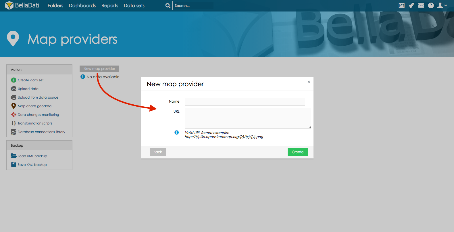
    2.  Click on New map provider. In the popup window name your map provider and paste its URL.

Image Removed

Sv translation
languageen
Note

Only users with data manager role can manage GEO points, regions and map providers. See BellaDati permissions and roles for details.

Panel

On this page:

Table of Contents

Info

BellaDati supports data visualisation on geo maps by using two options:

  • GEO Points
  • GEO Shapes
Map charts geodata screen

GEO Data Management

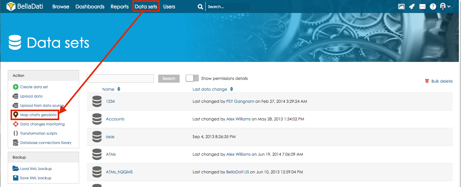
 In the Data set menu screen click on the Map charts geodata to manage GEO points, regions and map providers.

Available actions on Map charts geodata screen are:

  • Create point-based definition
  • Create definition of regions
  • Map providers: Use your custom GEO map provider - see Managing Map providers for more information.
  • Import GeoJSON: Allow to import predefined geo regions from file using GeoJSON format. See Importing GEO Regions (GeoJSONs) for more information.
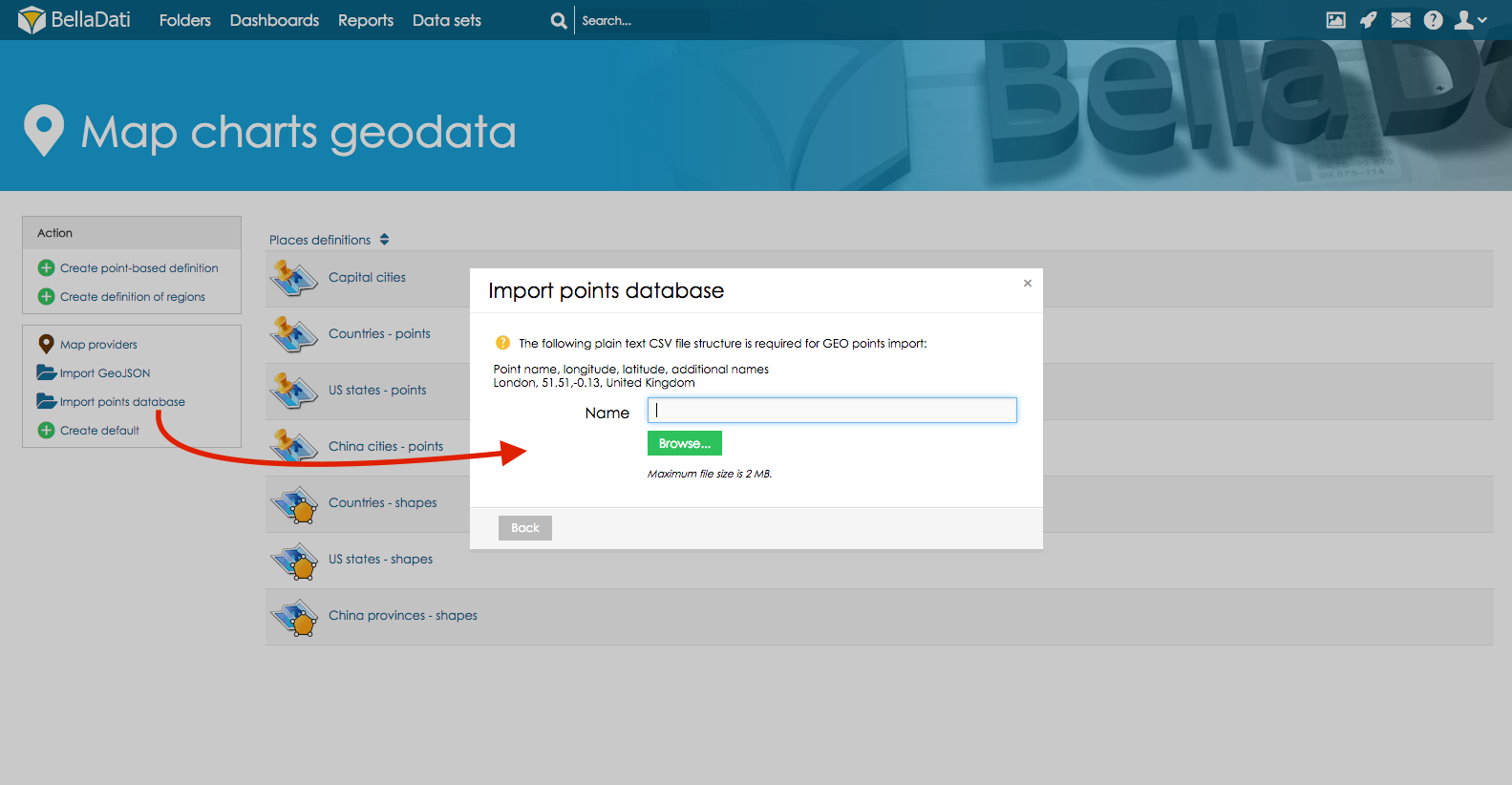
  • Import points database: Allow to import predefined geo points from CSV file in structure: point name, longitude, latitude, additional names. See Importing GEO Points definition for more information.
  • Create default: Will create default set of regions and points (countries, world capital cities, US states). That are delivered by default as part of BellaDati installation.

Image Modified

Uploading GEO Points definition


Note
titleGEO Points file format

Your CSV file with GEO location points must have exact format on picture below. Please note the delimiter type and no blank spaces are accepted. Each GEO point is defined by its latitude and longitude coordinantes. You have to define associated drill-down values to match drill-down members in the report view. You can associate more drill-down values to single GEO point definition. Upper and lower case are distinguished (eg. New York, new york, NY are different values).

Image Removed

This picture includes GEO POINTS for streets of Chicago city as following - Street Name, longitude, latitude (longitude and latitude exactly in this order)

In the Map charts geodata screen click on the Import points database and import CSV file in format described in the note section 
Image Removed
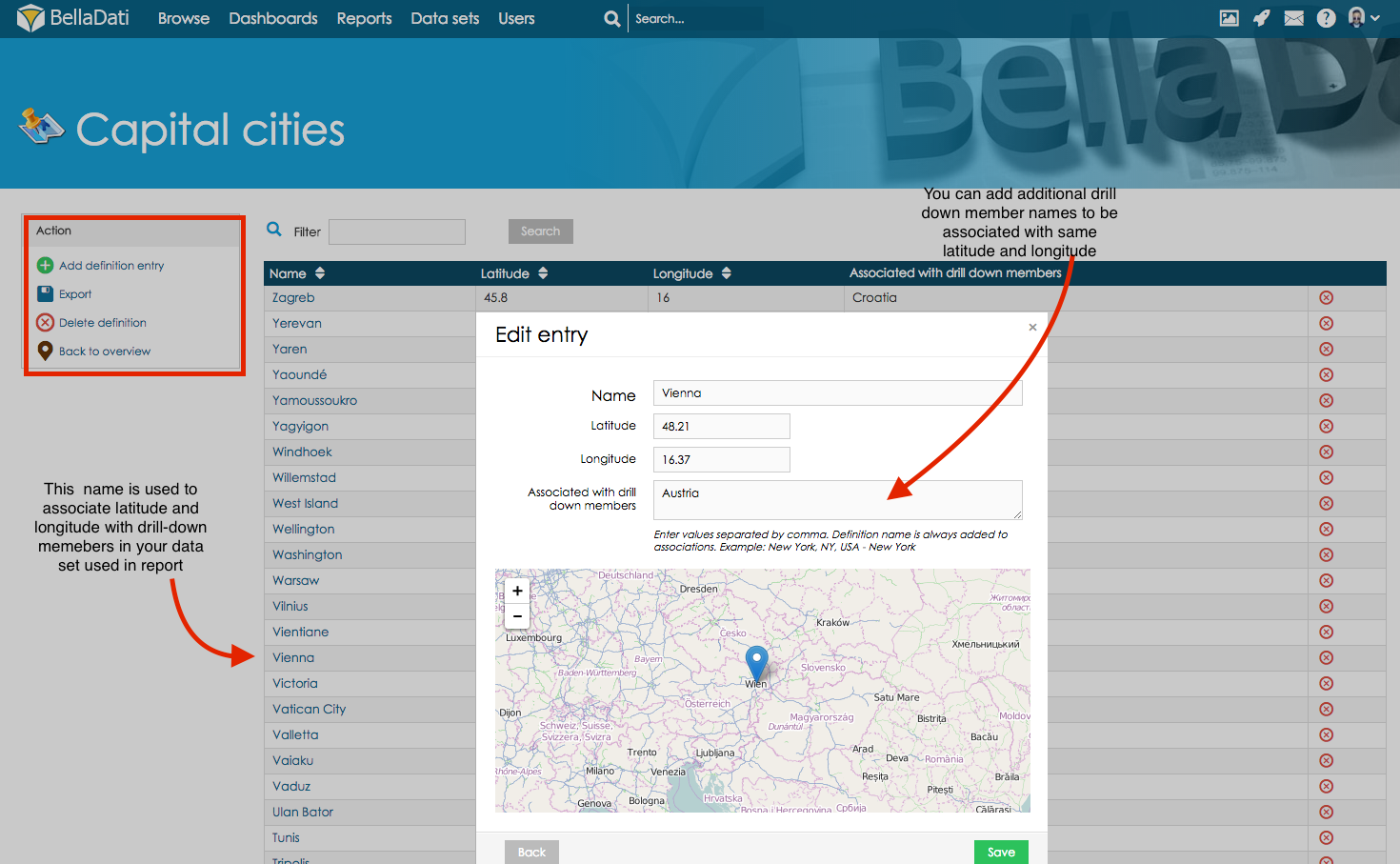
Click on the imported points data to edit data or proceed to report to create New Map
Following options are available
  • Add definition entry (to add new latitude and longitude definitions into the exiting definition)
  • Export option will export existing definition into the NameOfExistingDefinition.csv
  • Delete definition will delete existing definition
  • Back to overview will return user to overview of all available definitions


On the screen of the particular GEO points definition user can edit following parameters

  • Name, 
  • Latitude
  • Longitude
  • Associated drill-down values (multiple parameters can be inserted by using , as an delimiter)

Image Removed

Tip
titleAssociate with other drill-down members

Name of the GEO point will be associated with drill-down members in your data set used to create new map in report. Using Associated with drill-down members section you can associate latitude and longitude as well with other drill-down member. Example - City of Vienna has got associated latitude and longitude in Geo Points definition. If your data set includes as well state Austria. You can define it in Associated with drill-down members section and same latitude and longitude will be associated with Austria.

tip

GEO Regions

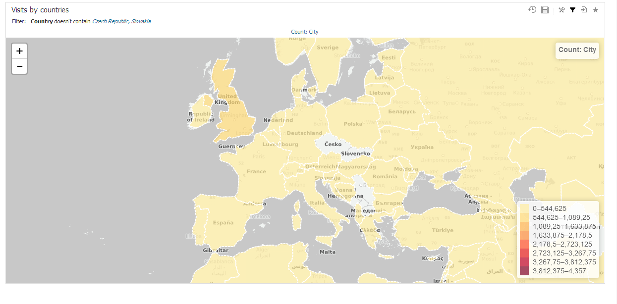
Each GEO region is defined by three or usually more points specified by latitude and longitude coordinantes. Standardized GeoJSON format is supported to simplify importing these definitions. You have to define associated drill-down values to match drill-down members in the report view. You can associate more drill-down values to single GEO region definition. Upper and lower case are distinguished (eg. Canada, canada, CAN are different values).

Following parameters are manageable for GEO regions:

  • Definition name
  • Region parameters: Name, GeoJSON coordinantes, Associated drill-down values

Image Removed

Map providers
Anchor
providersproviders
Note

Follow the valid URL format example using the OSM standard. You can refer to OpenStreetMap wiki for more information (section "Tile servers"). In case you are using only one server, parameter {s} is not used.

Creating own map tile server

Note

Own map tile server is very resource-demanding and requires powerful server with big storage. In most cases it is better to use default map provider.

We suggest using this tutorial for installing and configuring your map tile server. It is compatible with Ubuntu (tested on version 14.04). More info can be found here:

Maps can be downloaded from these links:

After successful start of server, copy the URL (or IP adress) and paste it in BellaDati in correct format (see Map Providers above)

titleTip how to upload geo data other way

Include the GEO point definition in the regular data import mapping the longitude/latitude to the GEO Point attribute type. But if you need to use Show details for option during creating new maps in report import GEO data trough Map Charts Geo Data section as described below.

Sv translation
languagesk

BellaDati podporuje zobrazovanie dát v mapách dvomi možnosťami:

  • GEO body
  • GEO tvary

Pre spravovanie bodov a tvarov kliknite na "Geodata pre mapy" v ľavom menu na stránke zoznamu skupín dát.

Note

Iba používatelia s rolou manažér dát môžu spravovať GEO body a regióny. Pre ďalšie informácie prejdite na role a oprávnenia.

Dostupné operácie

  • Vytvoriť definíciu bodových miest
  • Vytvoriť definíciu regiónov
  • Importovať GeoJSON: Importuje preddefinované geo regióny zo súboru vo formáte GeoJSON.
  • Importovať databázu bodov: Importuje preddefinované geo body zo súbory CSV. Štruktúra súboru by mala byť: názov bodu, zemská šírka, zemská dĺžka, ďalšie názvy
  • Vytvoriť základne definície: Vytvorí základné definície regiónov a bodov (štáty, hlavné mestá, štáty USA).

GEO body

Tip

Pri importe do skupiny dát môžete zaradiť GEO dáta do GEO atribútu.


Každý GEO bod je definovaný jeho zemskou šírkou a dĺžkou. Aby sa GEO body naviazali na jednotlivé hodnoty atribútov musíte im tieto hodnoty priradiť v nastaveniach bodu. S jedným GEO bodom môžete asociovať viacero hodnôt atribútov. Pri zadávaní sa rozlišujú veľké a malé písmená (napr. New York, new york, NY sa chápu ako rozdielne hodnoty).

Pre GEO body sú nastaviteľné nasledujúce parametre:

  • Názov definície
  • Parametre body: názov, zemská šírka, výška, združené hodnoty atribútov

GEO regióny

Každý GEO región je definovaný tromi alebo viacerými bodmi určenými podľa zemskej šírky a výšky. Štandardizovaný GeoJSON formát je podporovaný pre zjednodušenie importu týchto definícií. Pre zobrazenie regiónu v reporte musíte v jeho nastaveniach nastaviť združeného hodnoty atribútu. Podobne ako GEO point môže mať región pridelených viacero hodnôt atribútu. Pri zadávaní sa rozlišujú veľké a malé písmená (napr. Canada, canada, CAN sú chápané ako rozdielne hodnoty).

Nasledujúce parametre sú nastaviteľné pre GEO regióny:

  • Názov definície
  • Parametre regiónu: Názov, koordináty GeoJSON, združené hodnoty atribútu

Kam ďalej

Sv translation
languageja


Note

データ管理者の役割を持つユーザーのみがGeoポイント、地域、マップ提供者を管理できます。詳細はBellaDatiのPermissions and Rolesをご覧ください。


Info

BellaDatiは、2つのオプションを使用して、Geoマップでのデータの視覚化をサポートします:

  • Geoポイント
  • Geoシェイプ

Geoデータの管理

データセットメニュー画面のマップチャートGeoデータをクリックし、Geoポイント、地域、マップ提供者を管理します。

マップチャートGeoデータ画面での可能な操作は:

  • ポイントベースの定義の作成
  • 地域の定義の作成
  • マップ提供者: カスタムGeoマップ提供者を使用 - 詳細はマップ提供者の管理を確認してください。
  • GeoJSONのインポート: GeoJSON形式を使用して、ファイルから事前定義された地域をインポートできます。詳細はImporting Geo Regions (GeoJSONs)をご確認ください。
    • インポートポイントデータベース: 構造内のCSVファイルから、定義済みのGeoポイントをインポートできます: ポイント名、経度、緯度、追加名。詳細はImporting Geo Points definitionご確認ください。
  • 標準の作成: デフォルトの地域とポイント(国、世界の首都、米国の州)のセットを作成します。BellaDatiのインストールの一部として、デフォルトで提供されます。

Image Added

 次に

Sv translation
languagede
Note
Nur Benutzer mit der Rolle des Datenmanagers können GEO-Punkte, Regionen und Kartenanbieter verwalten. Weitere Informationen finden Sie unter BellaDati Berechtigungen und Rollen.
Panel
Auf dieser Seite:
Table of Contents
Info
BellaDati unterstützt die Datenvisualisierung auf Geokarten durch zwei Optionen:
  • GEO-Punkte
  • GEO Formen

GEO Datenmanagement

 Klicken Sie im Menü Dataset auf die Geodaten der Kartenkarten, um GEO-Punkte, Regionen und Kartenanbieter zu verwalten.

Image Added

Verfügbare Aktionen auf dem Geodatenbildschirm von Kartendiagrammen sind:

  • Punktbasierte Definition erstellen
  • Definition von Regionen erstellen
  • Kartenanbieter: Verwenden Sie Ihren eigenen GEO-Kartenanbieter - siehe Verwalten von Kartenanbietern für weitere Informationen.
  • GeoJSON importieren: Ermöglicht den Import vordefinierter Geo-Regionen aus einer Datei im GeoJSON Format. Weitere Informationen finden Sie unter GEO-Regionen (GeoJSONs) importieren.
  • Importieren Sie die Punkte-Datenbank: Ermöglicht den Import von vordefinierten Geopunkten aus der CSV-Datei in der Struktur: Punktname, Längengrad, Breitengrad, zusätzliche Namen. Weitere Informationen finden Sie unter Definition von GEO-Punkten importieren.
  • Standard erstellen: Erstellt einen Standardsatz von Regionen und Punkten (Länder, Welthauptstädte, US-Bundesstaaten). Diese werden standardmäßig im Rahmen der BellaDati-Installation ausgeliefert.

Image Added

Nächste Schritte